FLOOD
Flooding is generally a temporary inundation of water onto normally dry land areas by overflow of water, an unusual rapid accumulation, mudflows, or runoff of surface waters from any source. Flooding is the most commonly occurring hazard in Utah despite the state being one of the driest parts of America. It occurs in Utah in many ways. It can be sudden or slow. It can affect mountain streams or slot canyons many miles from any rainstorm. It can even occur far from any river or other water body. Understanding the many forms of flooding in Utah is helpful to guide mitigation measures. Notably, floods in Utah are not only the most common but also the most expensive hazard. Of all the natural disasters occurring in Utah, floods consistently carry the highest price tag year after year. This underscores the critical importance of comprehensive flood preparedness and mitigation strategies to safeguard both the state's residents and its economic interests.
Additionally, Utah's unique geographical features contribute to its vulnerability to flooding. The state's varied topography, including steep canyons and arid plateaus, can lead to rapid runoff
during intense rainfall. Urban areas, with their impervious surfaces, can exacerbate flooding, creating challenges for drainage systems. Moreover, the proximity of many communities to rivers and streams further amplifies flood risks. As climate patterns evolve, understanding and addressing these localized vulnerabilities will become even more crucial for effective flood risk management in Utah.
Development changes in Utah, such as urbanization, infrastructure development, and alterations to natural landscapes can contribute to an increased risk of flooding in the state.
Throughout the state, Kane and Washington county have the highest annualized flooding frequency, followed by Garfield, Wayne, and Grand county. The expansion of urban areas can lead to increased impervious surfaces like roads and buildings, reducing natural water absorption. This can result in higher runoff during storms, increasing the risk of flash floods. The construction of dams, levees, and other infrastructure can influence local hydrology. While these
structures are often designed to manage water flow, improper planning or maintenance can lead to increased flood risks.
The implementation of sustainable practices and the establishment of resilient infrastructure
are essential measures to reduce the impact of floods and safeguard Utah communities form potential consequences arising from extreme weather events. Local authorities and environmental agencies frequently assume pivotal roles in enforcing regulations aimed at mitigating flood risks associated with development.
The counties experiencing the most development pressures in the state all participate in the NFIP, requiring adherence to floodplain management regulations. Despite the pressures from population growth and increased development being felt in many counties, the overall flood risk should not be increasing, assuming local floodplain regulations and standards are being effectively implemented and local mitigation measures to curb stormwater runoff are taking place. An analysis of development trends in LHMPs (see Section 3.7 Development Trends and Table 3-3 specifically) did yield some concerns with flooding, notably in Emery, Toole, Weber counties. The southwestern counties of Beaver, Garfield, Iron, Kane, and Washington also noted expanding development potentially raising risk with flooding. Grand County noted a top priority was to create more open space in 100-year and geologic hazard areas. Urbanization contributing to more runoff was also noted in some of the rapidly growing counties along the Wasatch Front.
However, significant flood losses often occur outside of mapped flood hazard areas, accounting for approximately 40% of NFIP flood insurance claims. Rural areas often have outdated flood hazard mapping or none at all, making floodplain management and risk determination more challenging. More extensive and improved flood hazard mapping should improve flood risk determinations to existing and future development over time, though the areas experiencing the most growth are mapped. Given long-term climate trends including the potential for more extreme precipitation events that could exceed mapped flood hazard areas, coupled with increased development and increased runoff associated with urbanization, flood risk may still increase despite efforts to reduce this risk.
 Read the entire flood chapter
CASE STUDY
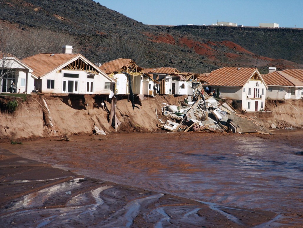
In January 2005 a rain-on-snow event resulting from a stalled storm system brought abundant precipitation throughout the state of Utah causing severe flooding along the Santa Clara River in St. George that led to extensive damage to homes in the area estimated at $300 million dollars.
In the aftermath of this flooding event, St. George began taking steps to become one of Utah’s 10 cities that have adopted the Community Rating System (CRS,) a program that encourages community floodplain management activities that exceed the minimum National Flood Insurance Policy (NFIP) standards. Depending upon the level of participation, flood insurance premium rates for policyholders living in a CRS community can be reduced up to 45%. Besides the benefit of reduced insurance rates, CRS floodplain management activities enhance public safety, reduce damages to property and public infrastructure, avoid economic disruption and losses, reduce human suffering, and protect the environment. Technical assistance on designing and implementing some activities is also available at no charge.
The Utah Division of Emergency Management in collaboration with FEMA provide classes and trainings annually to floodplain administrators throughout the state in preparation for the Certified Floodplain Manager exam. Community visits, CCO's, CAV's, and CAC's by state employees also help verify that communities are implementing ordinances and following them and providing mitigation strategies to at-risk areas throughout Utah. The Natural Resources Conservation Service (NRCS) funds many flood mitigation projects every year in Utah through its Emergency Watershed Protection Program.
Since 2014, the Utah Risk MAP Program, through FEMA CTP grants, has provided approximately $1,287,000 in LiDAR (laser surveying) acquisition funding to acquire areas within the counties of Salt Lake, Utah, Cache, Washington, Juab, Sanpete, Millard, Sevier, Piute, Garfield, Kane, Box Elder, and Weber. The state's goal is for 100% LiDAR coverage in collaboration with our Risk MAP partners with the Utah Automated Geographic Reference Center (AGRC) and the Utah Geological Survey (UGS) to provide funding and acquisition areas.