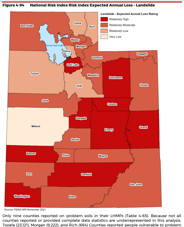
GEOLOGIC HAZARDS
Geologic hazards are those geologic conditions that present a risk to life (injury or death), of
substantial loss or damage to property, or damage to the environment. Geologic hazards affect
Utah, negatively impacting life safety, health, property, and the state’s economy.
Geologic hazards are defined in Utah Code as a “geologic condition that presents a risk to life, of
substantial loss of real property, or of substantial damage to real property” (Title 17, Chapter 27a,
Section 103.3). Geologic hazards commonly encountered in Utah include, but are not limited to:
Landslide Hazards, including:
- Landslides
- Rock fall
- Debris flows
Problem Soil and Rock Hazards, including:
- Breccia pipes and karst
- Caliche
- Collapsible soils
- Corrosive soil and rock
- Expansive soil and rock
- Gypsiferous soil and rock
- Liquefaction
- Land subsidence and earth fissures
- Piping and erosion
- Radon gas
- Salt tectonics
- Shallow bedrock
- Wind-blown sand
Volcanic Hazards, including:
- Volcanic eruption and lava flows
- Airborne volcanic ashment.
While many geologic hazards are not life threatening, they are often costly when not recognized
and properly accommodated in land-use management and project planning and design, and
result in significant construction or future maintenance costs, economic losses, and injury or
death.
Damages as the result of many geologic hazards are often not covered by property or other
insurance. There are exceptions and each policy should be reviewed for what damages are
covered or excluded.
Homeowners’ property policies generally cover all-risks or perils (property losses and damages),
except for those specifically excluded. Common exclusions are damages from earth movements,
earthquakes, mudflows, mine subsidence, sinkholes, flooding, and environmental factors.
Special policies may be available to cover specific named perils. Homeowners may be able to
get coverage for generally excluded losses by adding them to an existing policy by endorsement
or by the purchase of a separate policy. A difference in conditions policy provides coverage for
some otherwise excluded perils and is also known as a insurance companies will not extend earthquake insurance policies to unreinforced masonry (URM) buildings.
Multiple types of commercial property policies are available; however, earth movements such as
earthquakes, mudflows, mine subsidence, sinkholes, and flooding are commonly excluded.
Similar to homeowner property policies, earthquake insurance policies for URM commercial
development are severely limited. Endorsements can typically be added to a policy to provide
coverage for these perils and for expanding coverage for other perils.
Commercial auto policies have more options available, and coverage must be specified for each
vehicle or type of vehicle. Damages from geologic hazards may or may not be covered,
depending on the policy. Personal auto policies generally cover all-risks or perils, including
geologic hazards, such as earthquakes, flooding, falling objects, volcanic eruptions, etc. for
individuals with collision and comprehensive coverage.
In almost all cases, it is more cost-effective to investigate and characterize potential hazards by
performing a comprehensive engineering-geology investigation to identify and characterize
geologic hazards and implement appropriate mitigation, rather than relying on additional
maintenance over the life of a project or incurring costly construction change orders and other
financial costs. The Utah Geological Survey (UGS) recommends living with and managing
geologic hazards by understanding what they are, where they exist, how large or difficult they
are, and how to effectively mitigate them.
To ensure that future development within Utah is protected from geologic hazards, the UGS
recommends that a comprehensive engineering-geology and geotechnical engineering
investigation be performed by licensed professionals for all development. Such investigations
provide valuable information on site geologic conditions that may affect or be affected by
development, as well as the type and severity of geologic hazards at a site and recommend
solutions to mitigate the effects and the costs of the hazards, both at the time of construction
and over the life of the development. Engineering-geology investigations and accompanying
geologic hazard evaluations may be performed independently or be included as part of a more
broadly-based geotechnical investigation before project engineering design.
Much of this chapter has been derived from the UGS Circular 122: Guidelines for Investigating
Geologic Hazards and Preparing Engineering Geology Reports with a Suggested Approach to
Geologic-Hazard Ordinances in Utah publication available at
https://ugspub.nr.utah.gov/publications/circular/c-122.pdf. As the UGS revises or develops new
geologic hazard guidelines, Circular 122 will be updated as appropriate. Refer to the URL link
above for the most recent geologic hazard investigation and report guidelines and related
information.
CASE STUDY
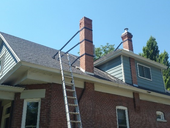
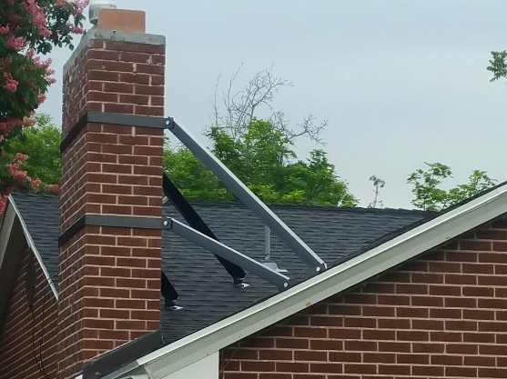
Salt Lake Fix the Bricks project to secure unreinforced masonry
Earthquake hazard mitigation strategies include encouraging building owners to purchase earthquake insurance and offering low-interest loans so residents can retrofit their homes. Salt Lake City's Fix the Bricks program utilizes FEMA grant money to help homeowners fund seismic improvements to eligible residential unreinforced masonry (URM) buildings.
Utah adopted the 2015 International Building and Residential Codes (IBC/IRC) statewide after July 1, 2016 specifying requirements for geotechnical investigations, including evaluation of some geologic hazards. Local governments can adopt stricter regulations for development projects in their cities or counties exceeding IBC/IRC standards. Municipalities with geologic hazard ordinances in place include the counties of Davis, Morgan, Salt Lake, Iron, Utah and Weber and the cities of Cottonwood Heights, Draper, Holliday, Salt Lake, and Sandy.
CASE STUDY
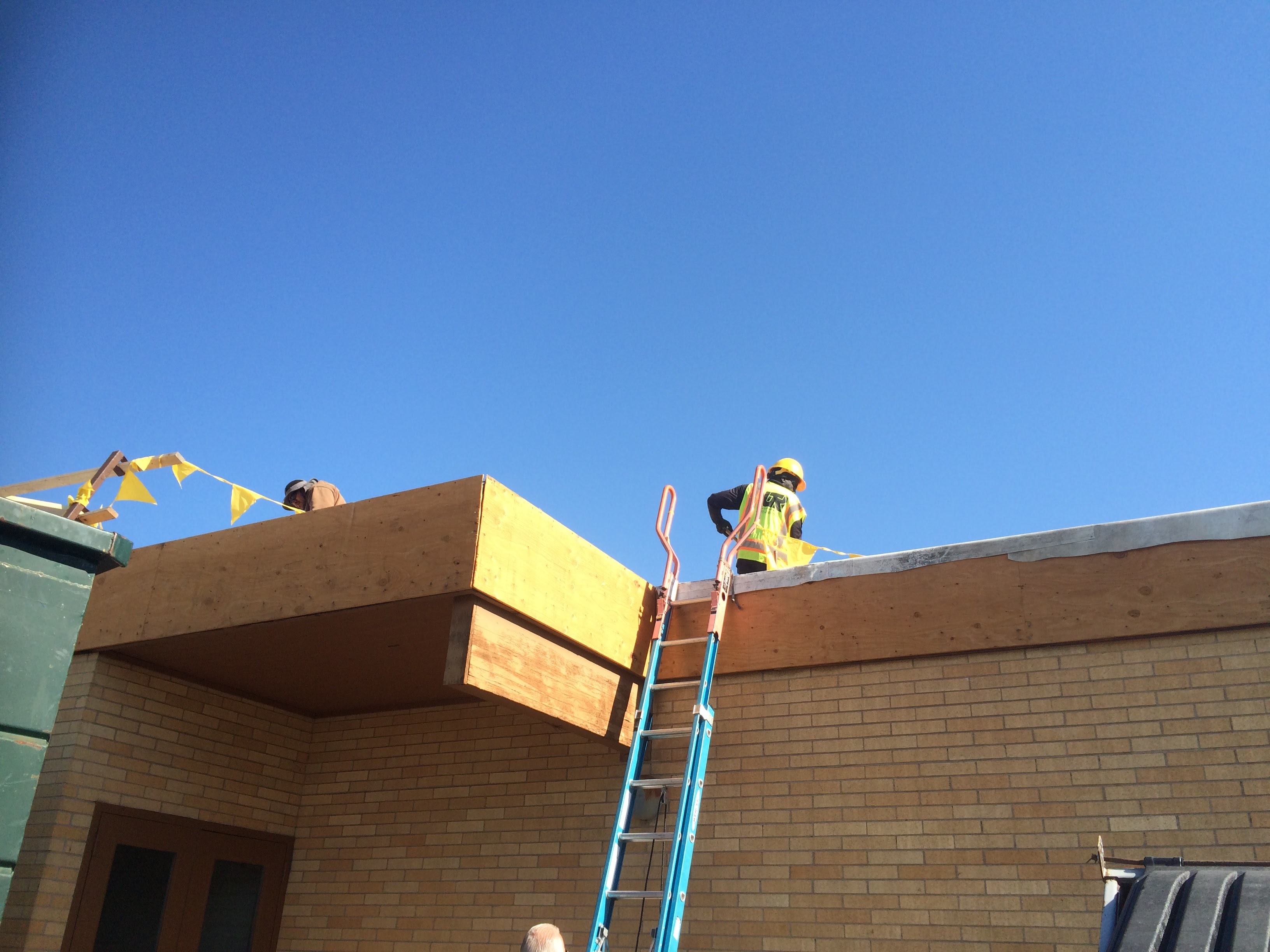
Horizon Elementary seismic project Murray School District
In 2013 Utah lawmakers approved a public school seismic study requiring all school districts that requested bond funding to perform structural seismic investigations on all buildings constructed before 1975. They allocated $150,000 for a School Building Earthquake Inspection Program.
In 2014 and 2015 the Murray School District secured FEMA grants with local matches totaling nearly $4 million to perform seismic retrofits on all of the K-12 schools in their district to make their more earthquake safe.
Utah’s Seismic Safety Commission has 15 board members that advise federal, state, local jurisdictions and the private sector on earthquake-related policy and loss-reduction strategies.